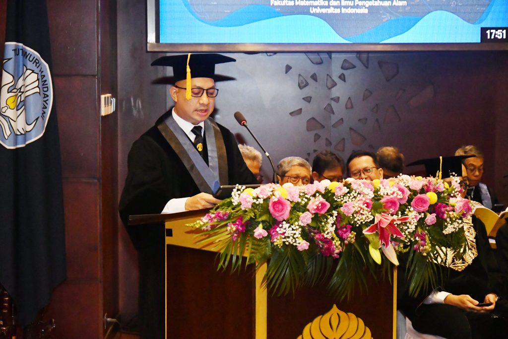
Universitas Indonesia (UI) inaugurated Prof. Dr. Tito Latif Indra, S.Si., M.Si., as a permanent professor in the field of Disaster Environmental Geography, Faculty of Mathematics and Natural Sciences (FMIPA), on Wednesday (15/1) at the Convention Hall, UI Depok Campus. At the inauguration led by UI Chancellor Prof. Dr. Ir. Heri Hermansyah, S.T., M.Eng., IPU., Prof. Tito delivered an inaugural speech entitled "Integrating Space-Risk-Resilience in Facing Disaster Challenges in Indonesia". He is the 6th Professor to be inaugurated at UI in 2025.
According to Prof. Tito, what he conveyed was based on concerns about the increasingly complex disaster conditions in Indonesia, a country blessed with geographical beauty but also faced with various disaster challenges. "Indonesia, a country with a complex regional constellation, stands on 4 active tectonic plates, namely the Eurasian, Indo-Australian, Pacific and Philippine plates," said Prof. Tito, Vice Dean II of FMIPA UI.
He added that Indonesia is also crossed by 2 volcanic mountain ranges, namely the Mediterranean and the Pacific Ring of Fire and its location on the equator which is influenced by the Inter-Tropical Convergence Zone (ITCZ) causes Indonesia to have a high level of disaster vulnerability. Based on data from the National Disaster Management Agency (BNPB) during 2023 there have been 4,940 disasters in Indonesia which are dominated by forest and land fires, floods, and extreme weather.
Spatially, disasters occur more frequently in areas experiencing massive deforestation and land conversion. On the other hand, the socio-economic impacts caused by disasters are increasingly significant, affecting more than 9 million people and damaging thousands of infrastructures.
Seeing the increasing and challenging disaster conditions and trends in Indonesia, Prof. Tito said that it is no wonder that the 10th and 12th Vice President of Indonesia, Jusuf Kalla, once said, "Indonesia is a disaster supermarket, it must be overcome with strength!" For that reason, this quote is a reflection that is relevant to the next context, namely about "utilizing" the power of technology, especially geospatial technology, in overcoming disaster challenges in Indonesia.
One of the greatest strengths that we can maximize is the power of geospatial technology. The rapid development of geospatial technology can be optimized to become one of the main tools in disaster management in Indonesia," he said. Currently, the development of geospatial technology has reached the stage of using cloud computing platforms in the mapping and data processing process. One of these platforms is Google Earth Engine (GEE).
GEE is a cloud computing platform that contains a collection of big data spatial satellite imagery for more than 40 years with high computing performance launched in 2010. This platform elaborates big data, cloud computing and artificial intelligence in the spatial analysis process and is an open access platform.
“Overall, geospatial technology is not just a map. It is a technological force that is able to integrate spatial data with various dimensions of risk and resilience. This technology allows us not only to understand threats more deeply, but also to design more effective mitigation and adaptation measures. In the context of Indonesia which is prone to disasters, mastering this technology is no longer an option, but an urgent need to protect society and the environment,” said Prof. Tito.
He emphasized that in facing increasingly complex disaster challenges, we must be able to integrate three main elements, namely space, risk, and resilience. A deep understanding of
Characteristics of disaster-prone areas or spaces, appropriate risk mapping, and strengthening community resilience capacity are the main keys in designing more effective and adaptive mitigation strategies.
“My research and service so far have focused on efforts to connect these three elements in a real context. With in-depth research, my team and I try to provide data-based solutions that can strengthen community resilience and minimize the impact of disasters. However, research alone is not enough without direct implementation involving the community, government, and other related parties. Therefore, it is important for us to collaborate more closely in designing disaster policies that are responsive and based on a synergistic understanding of space, risk, and resilience,” he said.
To date, he has done extensive research and writing on disaster mitigation and adaptation. Several of his scientific works have been published, including Synthesis of Decarbonization Strategies in the IKN Region based on Above Ground Carbon Sequestration (AGC) Loss Projections and Identification of Environmentally Aware Local Initiatives (2024); Cimandiri Fault Area and Surroundings viewed from a Physical Geography Perspective (2024); and Flood Disaster Prediction Model Using Long Short-Term Memory (LSTM) in Pekalongan (2023).
Before being confirmed as a UI professor, Prof. Tito had completed his undergraduate and doctoral education at UI. In 1998, he graduated from the Department of Geography, FMIPA UI. Still at the same faculty, he completed his master's education in 2002. Then, in 2013 he successfully obtained a doctorate from the School of Environmental Sciences (SIL) UI.
The inauguration was also attended by the Deputy for Empowerment of Disadvantaged and Certain Villages of the Coordinating Ministry for Community Empowerment Prof. Dr. rer. nat. Abdul Haris, M.Sc .; Deputy for Geophysics of the Meteorology, Climatology, and Geophysics Agency (BMKG) Dr. Nelly Florida Riama, M.Sc .; Director General of Land Acquisition and Land Development of the Ministry of ATR/BPN Ir. Embun Sari, M.Sc .; Member of the West Java Provincial DPRD H. Pradi Supriatna, S.Kom. M. M. S. I.; Elected Deputy Mayor of Depok Chandra Rahmansyah, S.Kom, M.TI .; Elected Mayor of Sukabumi H. Ayep Zaki; Elected Deputy Mayor of Sukabumi Bobby Maulana; and Deputy Director of Topography of the Indonesian Army Colonel (CTP) Ir. Supriyadi Amperanto, S.Si.