An earthquake measuring 7.4 on the Richter scale and resulting in a tsunami occurred in Palu and Donggala, Central Sulawesi on September 28 2018, destroying the city of Palu and its surroundings.
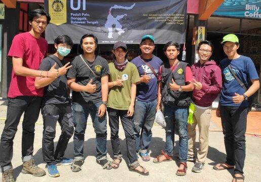
In order to support disaster management, the Department of Geography, FMIPA UI sent its students who were members of the UI Peduli Palu Action Team to map the areas affected by the devastating disaster.
They were divided into three teams, the first team namely Anggoro Tri Muldiguno, M. Naufal Fahrisa, Ahmad Fakhruddin, Abdurrahman Aslam departed for Palu on October 3-10, 2018, which was then followed by the departure of the second team namely Muhammad Faris, Dymas Trisna, Faatur Rahman Aditya Pratama, and Tomi Enjeri Siburian on October 10-17, 2018, and the departure of the third team namely Fuad Ramdhoni, Fernandos, Vita Khairunnisa, Rijali Isnaini Haripa on October 22-26, 2018.
They make maximum efforts to produce the latest data from recordings of natural phenomena in the form of maps.
Taqyuddin, S.Si., M.Hum. as a teaching staff of the geography department of FMIPA UI explained the importance of mapping disaster-affected areas is to detect and obtain data on the worst areas to areas considered the safest.
In addition, this mapping can also help operational interests in the field, such as sending logistical assistance to isolated victims to be moved to a temporary safe place (refugee camp), accessibility for officers and volunteers in evacuating victims.
"So that the evacuation of victims can be done quickly, the number of victims falling can also be minimized, (the delivery of) logistics also arrives quickly." He explained.
Regarding the method, Taqyuddin explained that the geography students conducted a direct field survey using GPS technology to collect spatial data, detect and document the areas crossed to get an idea of which areas were the worst and which were considered safe. And the results can be known directly because the data intracking secara online.
According to him, the results of this mapping are also very necessary as an effort to minimize future damage due to disasters that will occur repeatedly.
"Once upon a time it will repeat itself. So don't let infrastructure development with costs become in vain," he said.
He further explained that this work would be complete if safe places could be established to sustain the lives of the affected communities.
However, he admitted that carrying out mapping like this was not an easy thing, there were obstacles that his students had to face when carrying out the mapping, including:
no electricity, so you have to bring spare batteries for your equipment, the terrain is difficult to traverse on foot, and a foul odor is often smelled.
"So it requires courage, strong and trained physical and mental strength," he added.
News source: https://sci.ui.ac.id/