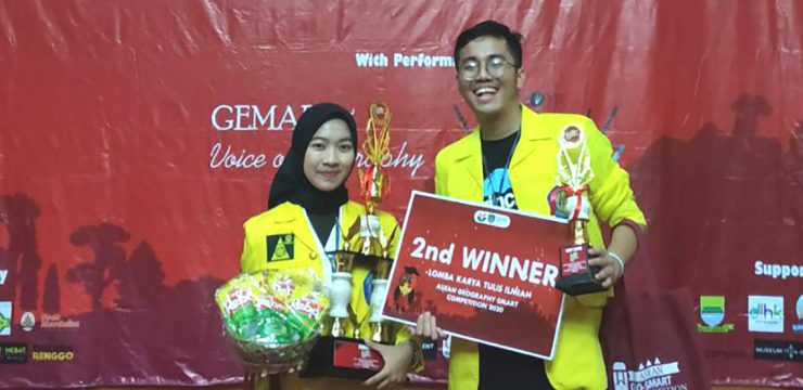
Two students from the Department of Geography, FMIPA UI, namely M. Attorik and Illa Annisa, succeeded in winning second place and the title of Best Paper in the event. ASEAN GEO-SMART Competition 2020 which was held on 12-13 February 2020 at the Indonesian Education University, Bandung, West Java.
They qualified for the top 10 stage or presentation stage after beating 50 teams from various universities in Indonesia who qualified for the next stage. Full Paper.
Their struggle could be said to be not easy to win second place in the competition with the theme Strategic Role of Youth Generation in Optimizing Environmental Conservation Through Geography Approach the.
The reason is, they have to prepare abstracts starting from November 2019. After being declared to have passed the abstract stage, they were busy creating scientific papers in December 2019, and in January 2020, they passed to the top 10 or presentation stage until finally, the jury team decided that the FMIPA UI team won second place on February 13, 2020.
The scientific paper they carried was entitled "Analysis of the Quality of Residential Environment in Realizing Sustainable Communities in Berkoh Village, Banyumas Regency".
In the scientific paper, both of them expressed ideas about the quality of the residential environment which has always been a concern in development issues, and has even become one of the 2030 sustainable development goals (SDGs), specifically goal 11, namely about Sustainable Cities and Communities whose main target is to ensure access for all decent, safe, affordable housing, including slum development, as well as access to basic services.
Through this research, the geography team of FMIPA UI attempted to determine the quality of the residential environment in Berkoh Village which is included in the KOTAKU (City Without Slums) program of Banyumas Regency, Central Java Province. To achieve this goal, this study used image interpretation methods and field survey methods.
Attorik said, "Interpretation of Sentinel 2-A Imagery in 2019 was processed to obtain information on physical parameters of the quality of the residential environment such as building density, building layout, width of access roads, condition of access roads, presence of shade trees and location of settlements, while field surveys were conducted to validate the results of image interpretation and obtain social data on the community environment such as social activities and community integration with the environment in the settlement by conducting interviews using purposive sampling techniques."
Continuing her colleague's story, Illa Annisa explained that the stage after obtaining information through the interpretation of the Santinel 2-A Image is to visualize the data or information into a map, using the Scoring method on each parameter to obtain analysis results on the quality of the residential environment in Berkoh Village which is divided into 9 residential blocks.
News source: https://sci.ui.ac.id/