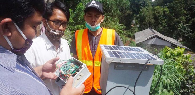
Landslide 2.0 by FMIPA UI, a Remote Landslide Detector Based on the Internet of Things

January 13, 2023

Depok, January 12, 2023. Based on data released by the National Disaster Management Agency (BNPB) on its official website, throughout 2022 there were 834 cases of landslides recorded in Indonesia. This disaster is the highest compared to tornadoes (635 cases) and floods (584 cases) from a total of 2,322 cases. As a result, 753 buildings were damaged, 735 residents were affected, and 7 people died

Seeing this condition, the Research Team from the Faculty of Mathematics and Natural Sciences, University of Indonesia (FMIPA UI) consisting of Dr. Parluhutan Manurung (Geography), Dr. Supriyanto (Geoscience), and Iskandar Koto, M.Sc. (Geoscience), developed Landslide 2.0, namely the Landslide Early Warning System (LEWS) for online landslide monitoring. By detecting changes in distance and slope in landslide-prone areas, this early warning system uses a laser distance sensor that is continuously operated from the monitoring location via cellular communication data transmission or Internet of Things (IoT) communication. Internet of Things (IoT).

The design, components, and workings of Landslide 2.0 are made as simple as possible to make it more affordable considering that landslides occur in almost all regions of Indonesia. This warning system is made more practical so that people from various groups can operate it. In addition, Landslide 2.0 is equipped with a radio to reach remote areas that do not have telecommunications access, and is equipped with a small 12 watt peak (WP) solar panel as an environmentally friendly energy source. With good maintenance, this tool can remain optimally used for five years.

The way Landslide 2.0 works is by monitoring changes in distance or cracks as an indication of ground movement through a laser rangefinder sensor placed on one side of the monitoring pole. The complexity of this change needs to be confirmed by monitoring the verticality or uprightness of the monitoring pole. If the measured distance change has exceeded the threshold, the system will provide a warning for users to avoid landslide-prone areas. The monitoring results are also transferred to the cloud server system to be displayed online and in real time on the website.
Dr. Parluhutan said that local monitoring in various landslide-prone locations can be integrated nationally so that land movement patterns in various regions can be analyzed comprehensively and completely. This community-based innovation technology is expected to support landslide risk reduction, especially in low-income settlements

"The innovation and independence of Landslide 2.0 technology is expected to be applied in various landslide-prone locations throughout Indonesia. The affordable price allows us to help communities and regional policy makers in building an independent early warning system in their respective regions," said Dr. Parluhutan.

Landslide 2.0, which began to be designed in August 2020, continues to be developed and improved to date. The tool has been tested for six months in the Bojong Koneng area, Bogor, West Java and has proven to be quite effective in monitoring land movement before landslides and sending early warnings in real time to the community. With a relatively affordable price, namely IDR 30-50 million, the community can operate Landslide 2.0 to build an independent landslide early warning system in their respective regions.

News source: https://sci.ui.ac.id/

Bagikan ini ke:
Berita Lainnya