Geography researchers from FMIPA UI who are part of the Expert and Research Team at the University of Indonesia (UI) have developed a WebGIS (Web Geographic Information System) Portal, namely an online map.
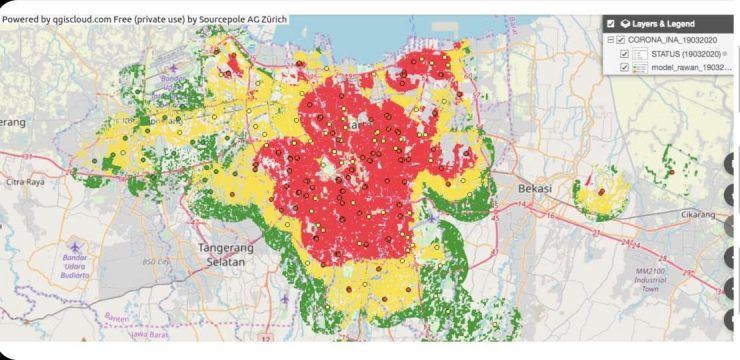
The development of this portal aims to assist the government in mapping the spread of the COVID-19 virus. The distribution map can be accessed via the page https://qgiscloud.com/ardiansyah18/CORONA_INA_19032020/.
This WebGIS will be able to map the population infected with COVID-19, the distribution of locations of patients who tested positive for COVID-19, and help the government map areas prone to new cases of infection. The WebGIS portal can be easily accessed via computer or smartphone.
Vice Chancellor for Research and Innovation Prof. Dr. rer. nat. Abdul Haris said, "The spread of COVID-19 has become a global concern, for that, we are trying to mobilize a team of UI Experts and Researchers to jointly develop an accurate map of the spread of COVID-19."
This spatial analysis portal was initially developed by Ardiansyah, a UI researcher from the Department of Geography, FMIPA, then completed together by a team of researchers from the Faculty of Computer Science (Fasilkom), Faculty of Medicine (FK), Faculty of Public Health (FKM), and Faculty of Mathematics and Natural Sciences (FMIPA) under the coordination of the Directorate of Innovation and Science Techno Park UI."
The information contained in this portal concerns the distribution of locations of patients who have tested positive for the COVID-19 virus; People under surveillance (ODP), and Patients under surveillance (PDP).
This map portal is also able to describe three classes based on their vulnerability status: Low, Medium and High. Areas classified as Highly Vulnerable (marked with red zones) are characterized by three things, namely, the number of sufferers domiciled in the area; the number and proximity of sufferers to public transportation facilities, and; high population density.
There are several parameters that are taken into account in the WebGIS Map, including the density of the number of sufferers in a certain area; the population density of each region, and; the density of the transportation system (train stations, bus stops, terminals, and others).
Data for this online map portal is collected from various sources of Regional Governments and Institutions such as the National Disaster Management Agency (BNPB), the DKI Jakarta Regional Government, the West Java Regional Government, and others. This portal is enhanced with input from researchers from the Department of Epidemiology, FKM, FKUI, Fasilkom, and from BUMN partners such as Telkom Indonesia.
"In intensive discussions between UI and PT Telkom Indonesia, Telkom's Big Data, Internet of Things (IoT) and Research Division has also expressed interest in collaborating and using this spatial analysis component to complement the portal and information system that they have built separately. In the future, it is hoped that the big data owned by Telkom as the largest cellular service provider in Indonesia can support data input for this portal and other portals that can help control the spread of the corona virus," said Vice Chancellor Haris.
It is expected that this WebGIS Portal can be useful for policy makers, both Regional Governments, the Ministry of Health, BNPB and other Ministries. This portal can also be an input for the community to increase awareness and independent anticipation in areas prone to the COVID-19 virus.
News source: https://sci.ui.ac.id/