The UI Geography Study Group (KSG) UKM collaborated with Esri Indonesia and the Geospatial Information Agency (BIG), holding the GIS (Geographic Information Systems) Day 2017 event on November 17-18, 2017.
First held in Indonesia to commemorate the celebration of World GIS Day which falls on Wednesday, November 15, 2017, the GIS Day 2017 event is packaged with various forms of events, namely: Talkshow, Student Competition, Amazing Race, Workshop, and GIS Gallery and Exhibition.
GIS Day is an international annual event that was first held on November 19, 1999.
Carrying the theme "Location-based Decision Making: A Technology to Enhance Sustainable Development", the 2017 GIS Day event is expected to support and realize sustainable development in Indonesia, as well as being a forum for professionals and parties interested in geospatial technology to demonstrate GIS applications (Geographic Information System) which can provide positive changes and impacts for society.
The entire series of events is open to students, academics, researchers, entrepreneurs, and the general public who are interested in the development and application of geospatial technology in relation to sustainable development.
One form of event held is technical workshop which focuses on understanding and applying the use of the ArcGIS Platform.
ArcGIS is a platform that brings various complex elements of GIS. In general, ArcGIS provides more complete tools to GIS to be able to interact more easily with spatial data.
ArcGIS is also equipped with customisation using the Visual Basic Application (VBA) environment so that this platform becomes easier and more capable.
This is very helpful for users, because almost all GIS software usually requires GIS skills and knowledge to operate it and is also relatively expensive.
ArcGIS is very helpful for lay users because of its capabilities, user interface, and the price is still affordable for the general public.
GIS is a field of technology that combines geographic features with tabular data to map, analyze, and assess real-world problems using spatial data of earth surface maps.
Depok, 25 Juni 2025. Indonesia, sebagai rumah bagi keanekaragaman hayati global yang luar biasa, menghadapi tantangan besar akibat alih fungsi lahan dan kebakaran hutan. Namun, Prof. Dr. Rokhmatuloh., S.Si., M.Eng.,
Depok, 25 Juni 2025. Sumber daya perikanan Indonesia berperan penting dalam ketahanan pangan, pendapatan, dan mata pencaharian, serta menjadi sumber protein hewani yang terjangkau bagi masyarakat miskin di pedesaan. Hal
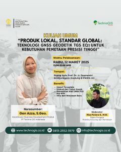
“Local Products with Global Standards: TGS EQ1 Geodetic GNSS Technology for High Precision Mapping Needs” This event will be held on:Day/Date: Wednesday, March 12, 2025Time: 13.00 – 15.00 WIBVenue: