As part of the commemoration of GIS (Geographic Information System) Day 2021 as well as in order to welcome the 62nd Anniversary of the Department of Geography, FMIPA UI through the Geography Department Student Association held Geography Days 2021 (The 13th G-Days) on July 19 to December 11, 2021. This event was supported by Esri Indonesia and Amazon Web Services, and Zoom Store ID.
Carrying the theme "Tackling Sustainability Problems with Spatial Science Collaboration", the holding of The 13th G-Days aims to ground geography among students, both high school students and students, stakeholders, and the wider Indonesian community as an effort to realize collaboration in achieving sustainable development goals (SDGs).
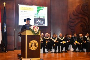
Dr. Rokhmatuloh, M.Eng. as the Acting Dean of FMIPA UI officially opened this grand event at the Opening Ceremony which was held online on Thursday, November 24, 2021.
In his speech, he said, "The development of Geospatial Science in the future will further accelerate Indonesia's progress into a modern and advanced nation, currently the progress has been seen with the development of industries that utilize geospatial information. FMIPA UI will continue to contribute in the field of geospatial science for sustainable development in Indonesia that reaches all levels of society, of course by collaborating with partners."
Meanwhile, the Head of the Geography Department of FMIPA UI said, "Through various series of G-Days activities, the community can broaden their horizons as widely as possible about the importance of geography for national development, its relationship to developing the potential of a region, to the impacts given from both social and economic aspects, especially now that the Department of Geography already has technology that can combine spatial data, maps, and tabular data."
He hopes that with the increasing public understanding of GIS technology and artificial intelligence technology in spatial aspects (Geo AI), multi-party collaboration in achieving sustainable development goals (SDGs) can be realized.
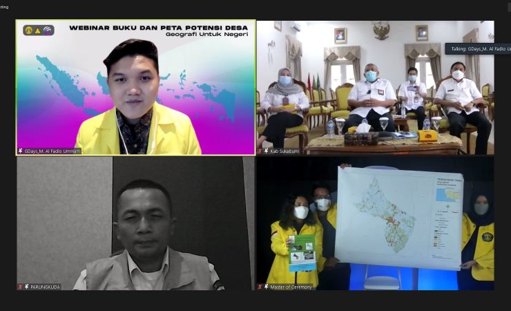
At the opening ceremony, a book and a map of village potential were symbolically handed over by the Head of HMD Geography Muhammad Al Fadio Ummam to representatives of the Sukabumi district government, namely Drs. H. Marwan Hamami, M.M. Regent of Sukabumi Regency, and Deden Sumpena S.Pd.I, M.Si. Head of Parangkuda District.
Both products are the work of students from the Geography Department, FMIPA UI from various classes as part of the community service program of the Geography Department, FMIPA UI for the residents of Sukabumi Regency.
Also present at this event was Budi Arie Setiadi, Deputy Minister of Village, Development of Disadvantaged Regions and Transmigration of Indonesia as a speaker on the webinar on village potential.
Through this webinar, he provides the latest insights on the importance of geography in the development process and development of village potential in Indonesia by utilizing detailed and measurable geospatial information.
"The role of disciplines, especially geography, in explaining the potential of the village is very much needed for sustainable development. We understand that building a village must be directed and measurable, directed in the sense that the path is clear, measurable means the stages are clear and precise so that the results obtained can be assessed together," said the Deputy Minister of Villages, PDTT.
He further emphasized that pentahelix cooperation is very important to encourage the process of national development progress.
"Building Indonesia starts from the Village, that's why we expect from this forum breakthroughs and innovative ideas will be born to provide solutions on how regional potential can be presented, described, and studied so that we can draw conclusions and the right steps in making direction and measuring Indonesia's development," he added.
Tristan Dimastyo Ramadhan as the Chief Executive explained that the 13th Geography Days has a fairly long series of events consisting of a Roadshow, Opening Ceremony, National Geography Olympiad (ONG), Onemap.id Challenge, Scientific Writing Competition (LKTI), GIS Workshop, Geographic National Society Summit (GNSS), and Geography Festival (G-Fest): Closing and Awarding Night as the closing of the series of events.
As an initial series of activities, a Roadshow was held from July 19 to August 20, 2021 to all high schools in Indonesia online, Registration to the announcement of those who passed the full paper Scientific Writing Competition (LKTI) in the period July 19 - November 25, 2021 and Registration to the closing of re-registration for the National Geography Olympiad (ONG) in the period August 16 to November 26, 2021.
Tristan added that there will also be an online workshop entitled "Exploring Geospatial Analytics with Amazon Web Services and ESRI by Using ArcGIS Urban" on November 19, 2021, followed by two online webinars in the series of Geographic National Society Summit (GNSS) activities that focus on the main theme "Collaborative Efforts and Innovation for Climate Crisis", namely Mini Webinar with the topic: Climate Crisis 1.0: Damaged Sea, Affected World and Mini Webinar Climate Crisis 2.0: Start Managing to Prevent Disasters respectively on November 20 and 21, 2021. Meanwhile, the peak of the GNSS webinar itself will be held on November 27, 2021 as a celebration of the 62nd Anniversary of Geography, FMIPA UI.
With this series of activities, it is not surprising that this event was attended by thousands of participants from various educational backgrounds and professions throughout Indonesia.
"All series of events have innovations to optimize the impact of The 13th Geography Days 2021 event, and this G-Days event has been attended by thousands of participants from various backgrounds," said Tristan to the FMIPA UI Public Relations team.