Author: Taqyuddin, S.Si., M.Hum (Lecturer in Geography, FMIPA UI)
An earthquake with a magnitude of 5 - 7.4 on the Richter scale and followed by earthquakes (less than 5 SR), at the end of September 2018, caused misery to the people of Donggala, Palu and Sigi. Worsened by the Tsunami and liquefaction, resulting in fatalities (> 1500 people), injuries, property and damage to government facilities.v
The community was made helpless to prevent it from coming. The government and the Indonesian people worked together to ease the burden, even international aid has arrived for rescue, rehabilitation and so on.
Learning and learning to deal with natural phenomena continuously cannot be stopped. How to learn from the event, to continue living in areas affected by the earthquake and tsunami, to reduce victims and losses? Disaster management concepts are already very piled up, but the concept of finding safe areas seems to be buried by liquefaction. That is what should be debated in detail, in detail and systematically. Studying safe areas in detail, then unsafe areas will be included in it.
To answer that question, it is not easy, but it is a lesson demanded by the people of Palu, Sigi and Donggala. If you want to avoid a tsunami, it can probably be done quickly, with the principle of staying away from the coast, but there are still questions if applied in the Donggala area which has a land width from west to east of no more than 25 km or as an isthmus in Sulawesi.
So Is there a safe place to live in this area? The hypothesis could be: 1. Yes 2. No. (academic assignment to research multi and cross-disciplinary).
What would you do if there was a “safe place” to live?
What to do if there is “no safe place” to live?
Questioning whether or not there are safe places from tsunamis and earthquakes in the Republic of Indonesia region requires hard work from multidisciplinary and cross-disciplinary science.
Why do social media and mass media report areas of danger, threats, and disasters? Even down to the details of the information. Are areas of danger, disaster, and threats the goal of development in that much detail? Of course not, but why waste time, money, and energy on things that are not the goal of development? As if "just find it yourself if you want to live safely in Indonesia".
Instead of the mandate of the nation's founders who wanted to be humane, just, protected, free, intelligent, orderly and peaceful, prosperous and prosperous, this is the narrative that was chosen and implemented in great detail as an ideal for the future. (variable continue), why bother with what is not narrated in the development objectives of discontinuous variables?
As an analogy if you want to be smart yes school, you can determine right, good, right, and valuable. Is it for being smart that we learn in school the opposite things for example do not associate with corruptors, do not break the law, do not insult, do notbully, do not be greedy, or this lesson is prohibited, that is prohibited? narratives of prohibitions, threats, dangers, disasters and so on can lead to achieving development goals? Why are we invited to be more fluent in understanding dangers and disasters, prohibitions but do not know which is right, true, good and more useful and continues to need to be reflected on together.
Apart from all that, currently natural events that teach its inhabitants lessons need to be studied and recorded, this is nothing more than a part of attention to support finding knowledge, understanding natural phenomena that are calming, namely finding safe places to live and continue development.
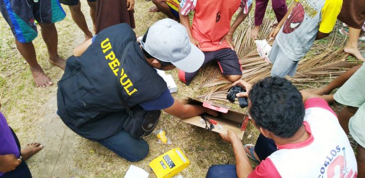
Tim pemetaan mahasiswa Geografi FMIPA UI yang tergabung dalam Aksi UI Peduli Palu, langsung menuju lokasi pascagempa dan tsunami di Palu. Mereka terbagi dalam dua tim pemberangkatan, pemberangkatan tim pertama pada tanggal 3-10 Oktober 2018 yakni Anggoro Tri Muldiguno, M. Naufal Fahrisa, Ahmad Fakhruddin, dan Abdurrahman Aslam. Di susul pemberangkatan tim kedua pada tanggal 10-17 Oktober 2018 yakni Dymas Trisna, Fatur Rahman Aditya Pratama, Tomi Enjeri Siburian dan Muhammad Faris.
This team is expected to work optimally and produce the latest data from recordings of natural phenomena in the form of maps. This is a very proud initial step, at least producing a map of building and environmental damage and helping to determine the right route to facilitate the delivery of logistics for isolated victims so that they can be moved to a temporary safe place (refugee camp).
This work will be complete if it can delineate safe places to sustain the lives of affected communities (with little or no disruption from development).
News source: https://sci.ui.ac.id/