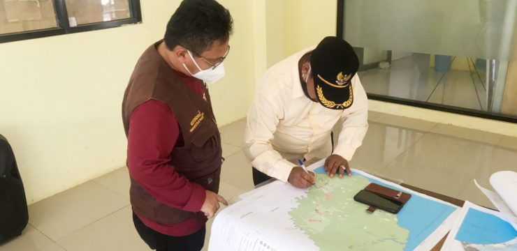
The Department of Geography, Faculty of Mathematics and Natural Sciences, University of Indonesia (FMIPA UI) held a discussion and validation of the Village Map in Ciemas District. Validation includes improvements to village boundaries, hamlet boundaries, sub-districts, types of land use, roads, rivers and naming (toponymy).
The activity carried out in the Ciemas District Hall, Sukabumi Regency on Wednesday, June 2, 2021, was part of the implementation of the community service program, involving the Sub-district Head and several Village Heads from Ciemas District, while still adhering to health protocols.
There are several maps introduced by the FMIPA UI Geography Department team, namely land use maps, geological maps, slope maps, geomorphological maps, soil type maps and river basin maps.
Head of the Geography Department of FMIPA UI, Dr. Supriatna M.T. explained that the activity has been routinely running for several years. This is done to introduce hard copy maps and digital maps of various map themes to 38 villages in six sub-districts, namely, Ciemas, Waluran, Cimanggu, Jampangkulon, Cibitung and Surade Sub-districts.
"This is a routine activity every year that we have run in the southern part of Sukabumi Regency. And so far we have succeeded in making 8 maps." Said the Head of the Geography Department, FMIPA UI.
The eight maps that have been successfully created by the FMIPA-UI Team are digital-based maps using Geographic Information System (GIS) technology.).
"The 8 maps that we have made include land use maps, point of interest maps, elevation maps, slope maps, geological maps, rock type maps, soil type maps and hydrological maps," he explained.
"Especially for land use maps, we discuss it with village officials first. Especially related to village boundaries, hamlet boundaries, road names and river names. Then after being corrected and improved, then we send the map to each village to be updated. Furthermore, the map will be entered into one of the applications. Furthermore, the village government can also edit the map," said Dr. Supriatna.
In addition to the discussion and validation of the village map, Dr. Supriatna, M.T. and the team also held training on completing the map contents by village officials or participatory mapping. The village map is a large-scale map as a tool for making various activities related to village government.
For example, mapping of village boundaries, RT, RW, reporting of various events, attractions with their locations without internet network, mapping of village planning, to mapping of various potentials such as agricultural potential, disaster potential and so on. "In addition, the potential for landslides and flash floods can also be mapped with the help of geographic information system (GIS) technology," he said.
"In addition to the map improvement discussion, training was also conducted on improving and updating digital maps by first downloading the Avenza Map application from each mobile phone device. Then a digital map of land use was provided in PDF format and the application was activated," he added to the FMIPA UI public relations team.
Training for village officials began with making improvements and adding map content to each using this application without an internet connection, only using the GPS device inside. smartphone each participant.
"The use of this application is very easy and we provide modules for training. Alhamdulillah, village officials are very enthusiastic in using this application, because it concerns what happens will be seen in their respective village areas," he explained.
"In addition, the potential for landslides and flash floods can be mapped with the help of geographic information system (GIS) technology," added the man who has been involved in mapping since 1986 in the South Sukabumi area.
According to him, the base maps in PDF format produced and given to the village government in Ciracap District are land use maps, important places or points of interest maps, geological maps, soil type maps, river flow maps, slope maps, elevation maps and geomorphological maps.
"These basic maps are used as materials to create village potential maps. Specifically, land use maps and important place maps are used to draw village boundaries, hamlet boundaries, sub-districts, RW, RT boundaries and reporting important places," he said.
On this occasion, the UI FMIPA Geography Department team introduced a 1:5,000 scale village land use map.
Specifically for the 1:5,000 scale digital land use map, continued Dr. Supriatna, M.T. made from high-resolution satellite imagery (CSRT) data, important points are added. Such as the location of the village office, market location, health center location and so on.
FMIPA UI provides hard copy and digital land use maps in PDF format A1 size and also submits hard copy village maps in A3 size, including rock type maps, slope maps, elevation maps, geomorphology maps, hydrology maps, land use maps and important places maps.
The Geography Department Team of FMIPA UI will improve the maps that have been validated and discussed with village officials at FMIPA UI, Depok Campus. The improved maps will later be delivered to each village along with the village potential book as part of the commemoration of the 62nd anniversary of the Geography Department of FMIPA UI.
"We will hold a handover event for around 80 village potential books and their maps in Sukabumi Regency, the work of students and lecturers of Geography FMIPA UI," said Dr. Supriatna, M.T. while ending his interview with the FMIPA UI public relations team.
He hopes that the discussion can increase the understanding and knowledge of the community, especially village officials, about the importance of mapping, so that they can make planning and policy decisions in managing and using mapped land wisely and prudently.
News source: https://sci.ui.ac.id/